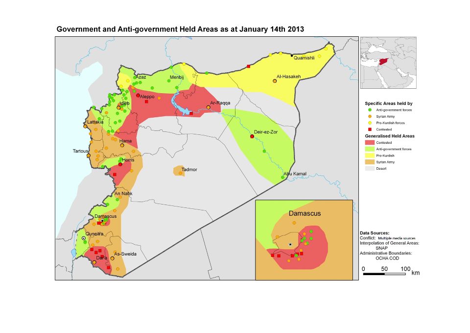
The map above was produced by the Relief Web website. Relief Web is a project of the United Nations Office for the Coordination of Humanitarian Affairs. The website, according to its homepage, aims to ‘provide reliable disaster and crisis updates and analysis to humanitarians, so they can make informed decisions and plan effective responses.”
The map purports to show an accurate breakdown of who controls what in Syria at the present time. But while broadly in accordance with the reality on the ground it contains at least one important error, which deserves to be pointed out, since adherence to the faulty map could have potentially disastrous consequences for visitors to Syria.
I’m concerned here with the part of the map dealing with Kurdish majority north-east Syria. I just returned from a reporting trip there, where I became aware of the map’s faults in a fairly practical way.
As you can see, the map depicts north-east Syria as controlled by ‘pro-Kurdish’ forces, which the map uses the color yellow to denote. The map accurately notes that the city of al-Hasakeh is controlled by the Assad regime’s army, whose color in the map is orange.
The map also accurately notes that the town of Sere Kaniyeh/Ras al-ain, which for some reason it nevertheless doesn’t name, is a ‘contested’ area (Arab rebels and Kurdish militiamen being the opposing sides in this contest.)
From there, however, the troubles begin. As observers will note, the map has the city of Qamishly colored in black. This is the only city in Syria colored in this way, and the map’s key does not explain what this coloring denotes. The map also has the area around Qamishly, and indeed the entirety of north-east Syria colored in yellow, indicating an uncomplicated reality of dominance by Kurdish forces.
This is an inaccurate depiction. In fact, Qamishly city and a considerable radius around it is in the hands of Assad’s army, as I discovered a couple of weeks ago when trying to reach Sere Kaniyeh from the town of Derik/Malkiyeh. Making this journey was essential for my reporting purposes, and its requires going through Qamishly.
Because I consulted sources other than the UNCHA map, I was aware that Qamishly was in regime hands. Still, I wasn’t prepared for the depth and extent of regime control. Qamishly city is filed with regime police, soldiers, flags, and a number of checkpoints.
I was travelling with a very experienced local Kurdish driver, and his wife, a translator. Because of this man’s local knowledge, we were able to avoid the checkpoints. As we drove west, the signs of regime dominance were still apparent, even 10 and 15 km outside the city. Regime flags, pictures of Bashar Assad, Ba’ath party banners.
As far as the town of Jawadiyah, maybe 20 km from Qamishly, the regime was in evidence, and in Jawadiyeh itself, a significant base is situated. After that, it was just a few minutes further drive before we hit the first checkpoint of the YPG Kurdish forces, and knew we were indeed back in Kurdish controlled territory. (And I, being in Syria without any formal permission, breathed for the first time in several minutes.)
The basic failure of the Relief Web map to conform with reality did not lead to any great consequences in my own case. That was due to the skills and knowledge of my hosts, and to my consulting of other sources. It is nevertheless, a notable professional failure.
The UN Office for the Coordination of Humanitarian Affairs has an overall global budget for 2012 of $285.4 million, according to its website. Possession of this sum, sadly, did not enable it to come up with a simple map outlining the division of forces in northern Syria which managed to approximate the actual situation. This is unfortunate. I write this article to caution journalists and others planning on working in Syria, and researchers and observers of the situation in that country against relying on the information provided in the Relief Web map of ‘Government and anti-Government Held areas’ of Syria, as published in January, 2013.

Thanks Jonathan. My wife and I had been considering a summer vacation in Qamishly, but given the uncertainties there, we’ll probably settle for Lyme Regis instead.
An excellent decision, I feel….
Jonathan, in your opinion are the Russian, Iranian and Iraqi governments supporting the Assad government in Syria?
Yes, without any doubt. And their support is a vital element in Assad’s ability to keep going.
What sort of support is it?
The Golan Heights colouring borders on the absurd…